
Monday, November 24, 2014
Tucson Mountains Trail Hound: Brown Mountain/Cougar Trail
We’re back with another edition of Tucson Mountains Trail Hound, again singling out one of the lesser known or under utilized trails in the Tucson Mountains, west of the city.
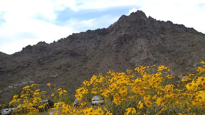
Hiking weather is officially, definitively here, so we can look forward to several months of pristine hiking weather. Today’s trail is the Brown Mountain/Cougar Trail loop, a beautiful, mid-level trail (really two trails) in plain view for everyone to see, but still seldom used.
Featured Trail: Brown Mountain/Cougar Trail loop
Approximate drive from downtown to trailhead: 20 mins.
Approximate length of trail: 4 miles + some change, roundtrip
Time: 3 hours with stops
Difficulty: moderate to medium, but there is some hill climbing, some of it on rocky trail surfaces
Highlights: split level trail, half below the mountain, half on top, with terrific views up and down; dense desert foliage and several exceptional stands of saguaros; easily accessible and under used trail in the heart of Tucson Mountain Park
To get to this trail loop, travel west on Speedway until it turns onto Gates Pass Road, follow it all the way over Gates Pass and down the backside of the pass until it connects with Kinney Road. Turn right on Kinney Road (like you’re going to the Desert Museum) and travel roughly 1/2 mile, taking a left on the McCain Loop road, which also says ‘Gilbert Ray’ at the turn off. There’s a pull off with parking for a few cars 1/4 mile down the road on the right, just before you get to the entry to the Gilbert Ray Campground. The trail head is to your left, almost back to the road.
Note: you can also enter via another trail head, at the Juan Santa Cruz picnic area, down Kinney Road a few miles, immediately before the Desert Museum.
The first 1/2 mile or so of this trail is the trickiest, as the trail splits a couple of times. Leaving the parking lot, you traverse the desert walking west and north, with Brown Mountain immediately in front of you. Follow the switch back down and across a good size wash, and up the other side into some very dense desert foliage. There are two (really three) signs to look for: the first is a battered wooden sign that says ‘Desert Museum 2.3 Mi’ and ‘Juan Santa Cruz Picnic Area 1.9 Mi’; follow that sign and NOT the newer one directly across the trail that says something about Brown Mountain loop, and leads off to the right to some picnic areas immediately off Kinney Road. The second says Cougar Trail, and you want to follow this as it bears to the right; that is, unless you want to do the upper, ridge line Brown Mountain Trail first, and loop back on the lower Cougar Trail; in that case, bear to the left, up the hill. It’s rocky.
After this the trick is to stay to the left, always, as there are a couple more, smaller trails that lead off to the right, to the picnic sites. One in particular has to watched out for, maybe 1/4 mile or less after the wash, as it’s easy to miss, and going forward looks initially like the correct path. There is a line of rocks directing you up the hill, but it’s easy to miss. But If you cross another wash, or see any picnic sites, backtrack and you’ll be fine.
From here it’s a mile and a half of relatively flat hiking in the lush Sonoran landscape, with beautiful saguaros and interesting rock formations unfolding along the Brown Mountain escarpment to your left. Kinney Road is to your right, and the main body of the Tucson Mountains beyond that. This is a bit of an idyll; another wonderful, accessible microcosm of the constantly astounding Sonoran Desert in all of it’s complex, multiple glories. We are blessed to call this home.
Towards the end of the Cougar Trail, just before a bend to the right, there is a leaking saguaro unlike anything else I’ve seen. A sheen of molasses brown liquid is running out of a gouge in a saguaro, creating thick, shiny coating that runs down to the ground. It has a musty pungent odor, and seems to have been running for awhile. I can’t imagine that this is healthy, but it’s yet another surprise in a constantly surprising environment, and one worth keeping any eye out for.
Eventually you’ll see the Desert Museum dead ahead (you’re still going north), and the trail will start to climb up and to the the west; you’ll get to a point where a sign says Gilbert Ray, and here’s where you reverse course back south, and onto the Brown Mountain Trail proper (although it’s not marked as such). From here it’s another 1 1/2 miles up the side of one small peak, then another, before you eventually settle onto a ridge line with spectacular views in all directions, including Kitt Peak and Baboquivari Peak to the west and south. You’ll also see Old Tucson Studios, the Gilbert Ray Campground and a terrific view of the west side of Gates Pass. This is some of the prettiest hiking in the whole north end of Tucson Mountain Park, perfect for sunset watching or catching a cool breeze. Eventually you’ll descend the mountain to the south, back down the trail and across the wash and back to the parking area.
REMEMBER: wear good shoes or boots. Although hiking in the Tucson Mountains is relatively easy, lots of the trails are rocky and have lots of loose, slippery rocks and such that are easy to loose your balance on. Twisting an ankle or taking a hard fall (hopefully not into a stand of cholla or prickly pear) miles down a trail pretty much sucks all the joy out of a hike.
Also: this area around Brown Mountain - and any of the trails close to the Desert Museum - are unusually populated with rattlesnakes. I’ve been told that this is because of leakage or run off from the underground irrigation/water system at the Desert Museum; the snakes are attracted to the water. Whether that’s actually true or not, a high percentage of the rattlesnakes I’ve seen while hiking in the Tucson Mnts. are in the area around the Desert Museum.
More, later.
The Trail Hound
Tags: tucson hikes , tucson hiking trails , tucson mountains hiking , Brown Mountain , Cougar Trail


© 2025 Tucson Weekly