
Wednesday, October 22, 2014
Tucson Mountains Trail Hound: Cat Mountain Trail
Page 2 of 2
Featured Trail: unnamed Cat Mountain trailApproximate drive from downtown to trailhead: 15 mins.
Approximate length of trail: 3 1/2 mile roundtrip
Time: 2 1/2 to 3 hours, depending on how many stops you make
Difficulty: moderate (but it is up and down)
Highlights: dense desert foliage and saguaros, shifting desert landscapes and views, up close and personal proximity to the desert, relatively quiet hike
Please note: all distances are approximates, based on guestimates, with help from a map or trail guide whenever possible. If something is off 1/4 mile or so, you heard it here first.
To get to this trail, travel west on Ajo Way until just past the #168 marker. Pull off to the right by a mail box, addressed 3840 Calle Paso Robles, and go straight ahead (north) a few yards to a tiny parking area that’s really only big enough for two vehicles. There’s a large metal gate and a ‘No Shooting’ sign; there’s also a break in the fence on the right, which is your trailhead. There are no other markers of any kind.
As far as I can tell, this is an unnamed trail, and one that runs the length of Cat Mountain, the biggest landmark at the southern end of the Tucson Mountains. It’s possible that it might include a little bit of the Explorer Trail that runs east/west, and is also in the same area, although further east, for the most part. This trail will lead you to a natural end point at the intersection of the Starr Pass Trail; at that point you can either turn around and make the trek in reverse, or take off either direction on the Starr Pass Trail.
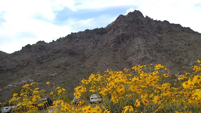
Passing through the fence will put you on a wide path heading north. Ignore the barking dogs by the gate on the left and proceed next to a fence and down and across a wash, which is where the trail really starts to get interesting. You’ll immediately find yourself in a very dense and picturesque section of trail with incredibly tightly packed foliage, saguaros and some great, low lying rock formations. The trail will veer to the left (west) and stay that way (more or less) for the length of the hike. At first, you’ll see houses off to the left, but they will quickly be left behind. Another trail (Explorer?) intersects at some point early on, but stay to the left and you’ll be fine.
This first piece of trail - no more than a couple of hundred yards in length after the wash - is one of my favorite spots in all of the Tucson Mountains. Between the rocks, the saguaros and the usual Sonoran mix (palo verde, ocotillo, creosote, mesquite, prickly pear, cholla, manzanita, etc.) of foliage large and small, this is a unique piece of trail, one where you can experience the desert unusually first hand, while still staying on a trail; the Sonoran Desert up close and personal, with everything Right Here, not just Over There.
Crossing another wash will bring you to a very well defined trail intersection; keep going straight (left), up the little canyon ahead. The right fork is also pretty, but soon leads to some houses and a little neighborhood, and pretty much dead-ends there. From there it’s a 20 minute walk up hill, with Cat Mountain on your left and more beautiful, Saguaro heavy ridge-lines on your right. Eventually you crest the hill and see the beginnings of the Starr Pass bowl area on your right; a 2 minute walk will bring you to a large set of sitting rocks on your left, and one of the prettiest views in the Tucson Mountains before you. Starr Pass Resort can be partially seen in the distance, as well as the back side of Tumamoc Hill and A Mountain to the east. This is a great spot to rest and take some photos.
From there a half hour walk - largely downhill - follows the rest of Cat Mountain over to where a cleft in the rocks leads to the Starr Pass Trail (not marked). You’ll pass a huge shade rock a little bit down this trail that’s a great place to beat the heat. The rocks at the end (at Starr Pass Trail) are spectacular, and totally unlike anything previously seen on the trail; they’re more smooth and stacked, and almost look like huge droppings of melted candle wax. I strongly suggest you go left (in a southerly direction) for at least a few minutes down this narrow passage way to check out the rocks in all their jumbled glory. There’s also an unusually appealing section of teddy bear cholla and beautiful, saguaro ringed ridges on both sides.
From there: reverse course, and you’ll be back at the car in a little over and hour. On the last leg, after you’ve passed the main intersection, be sure and stay to the left (and cross the wash), and not drift off where the trail goes straight ahead. That will eventually lead to some houses (and their dogs), I believe.
REMEMBER: take a knife! This is for prying those ubiquitous cholla droppings off of your shoes, boots, ankles, pants, and the occasional arm brushing up against the notorious jumping cholla. You don’t want to grapple with a cholla or chain fruit hanging off you with your bare hands; take a knife. And of course keep an eye on every single bit of brush and rock along side of the trail for curled up rattlesnakes.
More, soon.
Tags: carl hanni , tucson hiking , tucson mountain hikes


© 2025 Tucson Weekly